As our forested ecosystems become more susceptible to the risks of megafire, fire districts, counties, land managers, and utilities face critical challenges. To make the most impactful and informed land management decisions, they need access to high-resolution landscape data. Yet, traditional methods for gathering vegetation data have presented significant limitations.
For example, sending foresters into the woods to measure tree heights and diameters generates excellent quality data, but at very limited spatial scales. Aerial LiDAR (Light Detection and Ranging), which uses lasers mounted on airplanes or satellites to measure distance and then re-construct land surfaces and vegetation structure and height is expensive, inconsistently available, and quickly outdated by landscape-altering events like wildfire and drought driven disease.
For a more consistent, accessible representation of landscape vegetation across large areas, most organizations rely on canopy height models (CHM). However, not all CHMs are equally accurate. CHM methods are evolving rapidly, promising leaps in predictive performance that could help land managers reduce fire risks and restore and manage ecosystems faster and better.
Vibrant Planet’s CHM predictions lead the industry
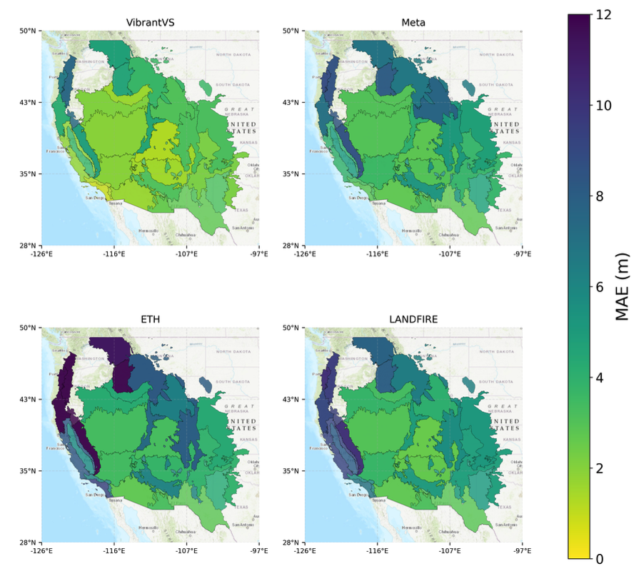
Recently, Vibrant Planet announced a breakthrough in our canopy height modeling. Findings show that our proprietary CHM, VibrantVS, provided on average the most accurate canopy height measurements compared to industry benchmarks from Meta, LANDFIRE, and ETH. The findings were also recently presented at the annual American Geophysical Union event.
One key metric of performance is mean absolute error (MAE), which measures the distance between a model’s prediction and an independent observation of the variable the model is trying to predict. Smaller MAE numbers represent more accurate model predictions. VibrantVS outperformed all 3 of the canopy height models we compared across the western US:
- VibrantVS Median MAE: 2.71 meters
- Meta DINOv2 Median MAE: 4.83 meters
- LANDFIRE Forest Canopy Height Median MAE: 5.96 meters
- ETH Zürich’s Global Canopy Height Model Median MAE: 7.05 meters

VibrantVS’s accuracy can be attributed to the model’s unique architecture, as well as a robust training process. The novel architecture affords the model to quickly identify fine details. Because of this, the model could train on large amounts of data - 45 million acres of LiDAR imagery, equal to 10 terabytes of data - and refine its fine-scale imagery predictions at a fast pace.

The foundation to more resilient forests
VibrantVS represents a major improvement in machine learning applied to environmental science. By synthesizing diverse geospatial datasets, the model creates a dynamic, consistent, and current view of forest landscapes that provides critical insights that can streamline fire modeling and project planning, including:
- Estimation of trees per acre
- Basal area calculations
- Timber volume assessment
- Canopy base height measurements
- Biomass/carbon quantification
These variables are critical for land managers, utilities, and fire protection districts looking to optimally site and finance wildfire risk mitigation projects, enabling improved understanding of hazard and risk, and more effective project planning and monitoring. Within our platform, VibrantVS contributes to the fine-scale segmentation of a landscape, grouping areas into units that are assigned fuel mitigation and management treatments. VibrantVS helps make projects generated on Vibrant Planet’s platform more realistic and faster to implement.
Dr. Andreas Gros, Vibrant Planet's Machine Learning Technical Lead, emphasizes the innovation's significance: "We're not just measuring trees; we're providing a tool that empowers land managers to make more informed decisions about forest health, wildfire and climate risk mitigation, and ecological restoration."
Better data for more efficient wildfire risk reduction
As wildfire seasons become increasingly severe and unpredictable, technologies like VibrantVS have transitioned from optional to essential. By bridging advanced machine learning with critical environmental management, Vibrant Planet is providing the kind of spatial specificity and temporal currency land and risk managers need at a fraction of the cost of LIDAR and commercial satellite data.
For land managers, fire districts, counties and states, insurers, conservationists, policymakers and more, VibrantVS is more than a model—it's a transformative lens for understanding and protecting our most vital natural resources.


